North and South Twin (12/30/21)
It's been a while since the last time that I did a blog post. I didn't hike for a while after the Appalachian Trail, but I have gotten back to hiking in recent months. I don't blog as often as I should because pulling photos off my iPhone is a pain, but I hope to get back to doing it more soon. Also, I hope to backfill some blog posts from some of the missed hikes.
It's winter again, so this blog post was all about continuing to work toward my winter list goals. At the beginning of this winter, I had four peaks still to go to complete my Winter 48 in New Hampshire. They were North and South Twin, Garfield, and Tecumseh. Tecumseh is an easy peak that I have been saving for my finisher so that my girlfriend Dragonfly can hike it with me. Garfield could be done in a day hike, but I want to do it as an overnight backpacking trip because I enjoy winter backpacking. The Twins are still on the list because they require a road walk, and that makes it a very long hike, difficult to finish with the short daylight in Maine in December.
My original plan for this week was to do the Garfield backpacking trip, but after coming back from holiday travel, I knew that I didn't have a backpacking trip in me. Thus, the alternative was the Twins. I figured that if I got out early and moved fast, I could get them done in daylight.
Unfortunately, my getting out early plan was foiled by a small snowstorm that popped up Thursday morning as I was leaving for the hike. The roads weren't terrible, but they were bad enough that I had to go more slowly, and that ruined my timetable. I grabbed breakfast along the way at Big Dave's Bagels and Deli in North Conway, and I highly recommend that place to anyone passing through the area.
Finding a place to park was difficult. The road that the North Twin Trailhead is on, Haystack Road, is closed in the winter. Thus, I had to take a separate road, Little River Road. I found a place to park at the Seven Dwarfs Inn. The office was closed, so a car next to me had left money for parking in a sealed envelope on their windshield. I wasn't comfortable with leaving money out in the open like that, so instead I left money on the dashboard, to let the owners know that I would pay for the parking as soon as I got back from my hike.
When I started hiking, it took me a little while to figure out which way to go. There were a lot of No Trespassing signs, so it wasn't clear how to get to Haystack Road and the North Twin Trailhead. Eventually, I discovered that if you go down a private road, there is a sign that points you towards a trail, and that trail links Little River Road to Haystack Road. Overall, it took me a mile and a half of hiking or so to get from the parking lot to the trailhead.
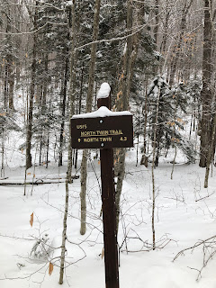
The North Twin Trail was quite easy at first. In fact, it was almost flat. I was carrying a ton of equipment with me, but I didn't need any of it for the first several miles of hiking. My snowshoes stayed strapped to my pack, and my spikes stayed in my pack.
Speaking of equipment, this hike was the debut of my new winter hiking system. I read The Last Traverse by Ty Gagne last year, and I came away believing that I needed to upgrade the emergency gear in my pack in case I get caught in a bad situation. I now carry a bivy sack, a sleeping pad, and a 20 degree quilt (basically a sleeping bag without a bottom) with me on winter hikes so that I can hunker down if I get into trouble and not be at risk of freezing to death or losing limbs to frostbite. The combined weight of the items is about three extra pounds, but my summer and winter hiking philosophies are very different. In summer, I am all about light and fast. In winter, I am all about heavy and safe.
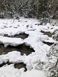
The winter hiking trail for North Twin is a little different from the summer hiking trail, as the winter path skips the first two water crossings. Given that the ice across the river looked dicey at best, I was grateful for this. However, I did still have to do the third river crossing (see picture below). I knew I would be fine for the morning crossing, as the ice bridges looked solid enough. However, I was concerned about whether I would be able to get back across in the afternoon. Nevertheless, I pressed onward.
Not long after the river crossing, the trail left the flat area behind and started to climb. I checked my GPS app (FarOut, which was formerly Guthook), and realized that I was going to have to gain 2000' of elevation in just over a mile and a half. That's steep! There was nothing to do for it, though. I put my climbing playlist on my bluetooth headphones, and I strapped on my new MSR Lightning Ascent snowshoes. These snowshoes have a much more comfortable binding system than my old Lightning Ascents, and they have the televator system which gives you a heel lift, making big climbs easier. In this case, I primarily wanted them for the televators, as I knew they would come in handy on a climb like that.
The climb was certainly tough, but after a mile or so of very hard climbing, it eventually started to ease off a bit. I came to an overlook on North Twin, and got a great view of Mount Washington peaking up through the clouds. Hopefully you can make it out in the picture below.

From the overlook, it was a fairly easy hike over to the North Twin summit. I grabbed a quick snack and took a summit selfie, and then moved on towards South Twin, which was another mile and a half further in. On the way, I was able to take a great photo of the sun peaking out through the clouds as I walked through the alpine pines.

This trail is known as the Twinway Connector, as it connects the North Twin Trail to the Twinway, which is actually the Appalachain Trail. I remembered that I tried to write a song about the Twinway back in 2017 when I first hiked the Twins. I didn't get very far, but here are the first few lines (to the tune of the Downeaster Alexa by Billy Joel):
Well I'm on the Twinway Connector,
And I'm heading back towards the AT,
My friends have gone on to Garfield,
But tonight it's just Galehead for me.
I've got boots from Bean and two new hiking poles,
I know this trailhead's here but where God only knows...
That's all I have so far. Maybe I'll finish it someday. Anyhow, the hike from North Twin to South Twin wasn't too bad. I remembered from my last hike that South Twin has a much prettier summit than North Twin, and boy was my memory correct. The views from South Twin were beautiful. One of the photos I got from South Twin was the picture below, which may be one of the prettiest hiking photos that I have ever taken.

I was already seven miles into the hike by the time I got to South Twin. I had made good time, but my legs were feeling it from hiking with the heavy pack and wearing the snowshoes. I knew it was time to turn around and start heading back. I was dreading the hike back up North Twin, but I figured the rest of it would all be downhill, and I was looking forward to that. I think downhill winter hiking is some of the easiest hiking that you can do.
I made it back to North Twin relatively quickly, and as I was leaving the North Twin summit I ran into the first other people that I had seen all day. I assume that they were a husband and wife hiking together, and they asked me if I was Pat. I gave them a quizzical look, and they explained that they had been following my tracks all the way up. They knew that I was wearing Merrell boots and MSR snowshoes, but they didn't know my name or my gender. They felt like they should give me a name, so they named me Pat. I gave them my real name, and we chatted for a few minutes. They seemed to be keeping a pretty good pace, so I figured that even though they were behind me, they probably wouldn't have to do too much hiking in the dark.
As for me, I kept a good pace going down. I did run into one other group, four guys that were going to camp at Guyot Shelter. I thought that they were too late in the day to make it to Guyot (at least in daylight), and I noticed that they were bare-booting, which was likely going to be a problem for them on the Twinway, but I kept my observations to myself. They were carrying a lot of equipment, and I figured that they had done their homework.
I switched back to bare-boots myself once I got done with the steep part of the descent down the North Twin Trail, and I was able to pick up the pace. Podcasts helped as well. I listened to a couple of hourlong podcasts that really helped pass the time. Before I knew it, I was back at Haystack Road. As I hiked down Haystack Road looking for the trail back to Little River Road, I noticed the sun setting beyond the mountains.

When I made it back to the Seven Dwarfs motel, I noticed a note on my windshield. They told me to leave payment for parking in the mailbox, so that is what I did. I was happy to be back at my car. My legs were really worn out, but I was proud of having hiked 14 miles in just seven and a half hours. I was also proud of knocking two more peaks off the list. Two to go! Remember, you can't take flight until you spread your wings.


Comments
Post a Comment