Washington (11/20/21)
I don't know why, but for a long time leading up to this hike, I couldn't get Mt. Washington off my mind. I really wanted to hike it, and I couldn't tell you a good reason why. Maybe I just saw it mentioned in too many books and YouTube videos. I have attempted to hike Mt. Washington four previous times (twice successfully), and all four times were from the west side of the mountain, via the Ammonoosuc Ravine Trail. In fact, you can read about the most recent of those attempts here on this blog.
This time, I wanted to do something different. The more famous approach to the big mountain is via the east side, starting from Pinkham Notch and ascending via one of several routes. The easiest route is probably the Boott Spur Trail, but it's also the longest. The most iconic route is via the Tuckerman Ravine Trail, but that area is also famous for avalanches. The most difficult route is Huntington Ravine, and I wasn't going to go near that in winter conditions. Thus, I decided to take the traditional winter route, using the Lion Head Trail. This route would require me to take the Tuckerman Ravine Trail until the Lion Head split-off, and then eventually rejoin Tuckerman just past the Alpine Garden above tree line.
I was taking no chances with this hike. I knew that there would be winter conditions, so I made sure to bring all potentially needed equipment with me in my car. I had snowshoes, an ice ax, and full crampons. I also had a sleeping bag tucked into my pack for emergencies. I was ready.
The hike starts from the Pinkham Notch Visitors Center, and it's traditional to check in with the rangers there to find out what conditions are before you start hiking. Part of the rangers' job is to weed out people who aren't properly equipped to be hiking Washington in winter conditions, so I was glad that they didn't try to dissuade me from my hike. The ranger I spoke to told me that the reports they had indicated that the best route of ascent was via Lion Head, and I wouldn't need any of the heavy equipment that I brought. Just my Hillsounds microspikes and my normal hiking poles would be enough.
As I started out on the Tuckerman Ravine Trail, the going wasn't too bad. I soon passed a family that had stopped on a bridge to take a picture. I patiently waited for their photo session to end before I continued. When they noticed me, the father jovially informed me that I could have kept walking through if I didn't mind being in their picture. I laughed and continued on.
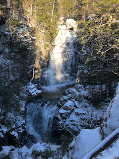
Not long after that, I came to an icy hill. I realized it was time to put spikes on. The family passed me again, and we met up again at a waterfall a short time later.
I passed the family for good not long after this. I thought about putting in my headphones, but I was actually enjoying just hiking in nature at this point, and decided that I didn't need the distraction.
The early Tuckerman Ravine Trail had a slight uphill to it, but not severe, so in some ways it was the perfect ascent. I always enjoy ascending gradually as opposed to steep sections where you're gaining a thousand feet in a mile.
I passed by the Huntington Ravine Trail. To climb that in summer conditions would be a challenge that would test my skill level to the max. In winter conditions, it wouldn't be possible to climb it without ice climbing gear. I wisely stayed on the Tuckerman Ravine Trail.
One cool feature of this hike was that Mt. Washington loomed before me for a good part of the hike, meaning that I always had my destination in sight. It looked a long way off, but I could tell that I was drawing ever closer. Eventually, I made it to the turn-off for Lion Head.
I knew this would be one of the steepest parts of the hike, and it didn't disappoint. If you're going to climb a six thousand foot mountain, you're going to have to gain elevation somewhere. There was one part of Lion Head that was so dicey that I wasn't sure how I was going to get back down it. I ran into a couple of guys who had ascended Lion Head for a sunrise hike and were now climbing back down. We chatted for a minute or so before we moved on. I give them credit for getting up early and ascending Lion Head in the dark. That's beyond my comfort level.
I finally broke tree line on Lion Head, and I could see the actual Lion Head formation off in the distance. I don't know why they call it Lion Head. It looks nothing like a Lion Head to me. Of course, Owl's Head doesn't look like an Owl's Head, either, so I have no idea where many of the mountain names come from. Take a look at the picture below and see if it looks like a Lion Head to you. It's the formation in the middle of the picture.

Once I got past the Lion Head formation, I moved into the Alpine Garden. Around this point, I started having a problem that I had never experienced before while hiking: serious leg cramps. I thought back to when I used to watch a lot of NFL games, and I remembered that oftentimes players would experience leg cramps while playing in hot conditions, usually due to dehydration. Thus, I decided to hydrate quite a bit, and that seemed to help the problem. It didn't recur for the rest of the hike.
The Alpine Garden was beautiful, but the snow in this section was deep, and it was the one place that I wished I had snowshoes. Thankfully, this was one of the flatter sections, and that made it a good recuperation area between steep sections. I eventually exited the Alpine Garden and rejoined the Tuckerman Ravine Trail. To my left was a great view of the ravine itself.

From here, the climbing was very tough. I was already tired from all the other climbing, and now it was rock over rock all the way up to the summit of Washington. I was very grateful when I finally emerged out onto the Auto Road. From there, it was a relatively simple climb up to the group of towers and buildings that represent the Washington summit.
Mt. Washington has such unique weather conditions that it leads to some very strange occurrences. Ice and snow can shape themselves in unusual ways up there. For an example of this, look at the sign below.

Of course, I also had to take a selfie with the summit sign. It's a tradition.

The summit was cold and windy, as it always is, but actually pretty tame for Mt. Washington. I was able to take shelter behind the closed Visitors Center and grab a quick snack before I started my descent.
The first part of my descent took me back down to the top of Tuckerman Ravine. From here, I had three options. I wasn't crazy about the idea of going back down Lion Head, as I knew there were dicey spots that I had seen on the way up. I could also descend via the Tuckerman Ravine Trail, but that involved a very steep descent through potential avalanche territory, so I quickly ruled it out. The third option was descending via Boott Spur Trail. I knew that Boott Spur was supposed to be the safest route, but I was worried about running out of daylight due to its length and ending up in territory that I didn't know after dark. I decided that to stick with the devil I knew and go back down Lion Head.
It turned out to be a smart move. Many of the dicey spots that I had been worried about were actually slightly easier on the way down than they had been on the way up, maybe because I was ready for them this time. I picked my way carefully back down to the early part of the Tuckerman Ravine Trail, and from there I was able to pick up good speed for the rest of the way down the mountain.
When I arrived back at the Pinkham Notch Visitors Center, I went inside to let the rangers know that I had made it out safely, and also to give them a conditions report. The ranger that I spoke to asked me a lot of questions, and I was happy to answer as many of them as I could. I probably spent half an hour talking to him before I headed back to my car. I stowed all my gear away, and started the drive home.
Normally this is where I would end the blog and say, "You can't take flight until you spread your wings." However, I didn't realize that my day wasn't over. As I was driving back through North Conway, NH, I got a call from my girlfriend Dragonfly. I knew that she had been hiking today in southern New Hampshire with her cousin. I assumed that she was just calling to let me know how her hike had gone and ask about my hike. Thus, I answered the phone in a jovial manner.
However, her voice was not jovial. It took a bit of explanation on her part to help me understand what had happened. Essentially, she and her cousin had used a car spot to do a point to point hike in the Squam Range. Unfortunately, the conditions were worse than they had expected, and that had slowed them down. They were now running out of daylight, and to make matters worse, they had only two bailout points: Mt. Morgan and Mt. Percival. Both peaks are on the Terrifying 25 list in New Hampshire for their combination of ladders and caves. Ladders and caves were two features that Dragonfly's cousin was not enthusiastic about, so they had to find a workaround. I told them that I would meet them at the Mt. Morgan parking lot, and I also promised to let Dragonfly's mother know about the situation.
I set my GPS for Mt. Morgan, and I called Dragonfly's mother. Thankfully, she was not panicked. I told her I would update her when I had more information.
When I arrived at the Mt. Morgan parking lot, I strapped on a headlamp and started up the trail looking for Dragonfly and her cousin. I wasn't carrying a pack so that I could move faster. I was maybe half a mile in when I found them. Fortuitously, it turned out that they had managed to find a workaround for the caves and ladders on Mt. Morgan just before they lost daylight. I helped lead them back out to the parking lot. Everyone was grateful for the warm car and that the ordeal was over.
I drove Dragonfly's cousin back to her car, and then Dragonfly back to her car, and I let Dragonfly's mother know that everyone was safe and sound. Between Washington and the Squam Range, it had been a long day, and I was glad that it was over. Now I can finally say, you can't take flight until you spread your wings.


Comments
Post a Comment